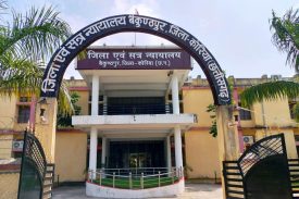
ABOUT DISTRICT COURT
Little is known of the area before the 16th century. Koriya was a princely state of British Empire in India; the other princely state that lay within the Koriya district was Chang Bhakar. After Indian Independence in 1947, the rulers of Koriya and Chang Bhakar acceded to the Union of India on 1 January 1948 and both were made part of Surguja District of Madhya Pradesh state.
The district of Koriya came into existence on May 25, 1998, when it was carved out of Surguja district. After the formation of the new state of Chhattisgarh on November 1, 2000, Koriya District became part of the new state. It is currently a part of the Red Corridor and as civil district korea came into existance on Oct 8, 2006.
Geography
Koriya District lies between 22°56′ and 23°48′ North and 81°56′ and 82°47′ East. It is bounded on the north by Sidhi District of Madhya Pradesh, on the south by Korba District, on the east by Surguja District, and on the west by Anuppur District of Madhya Pradesh. The area of the district is 5977 km², of which 59.9% is forest area. The district is a vast mass of hill ranges. The[...]
Read More- Public Notice dated 14-01-2025 regarding false assurance or inducement.
- Advertisement for contractual appointment in Legal Aid Defense Council Baikunthpur District Korea
- Advertisement for contractual appointment in Legal Aid Defense Council Kondagaon
- Work Distribution dated 01-01-2025
- Important information regarding written competitive examination for the post of Assistant Programmer.
- Notice regarding resolution of claim objection for the post of Assistant Programmer.
- Video Conferencing Links for National Lok Adalat 14-12-2024
No post to display
eCOURT SERVICES

CASE STATUS
CASE STATUS

COURT ORDER
COURT ORDER

CAUSE LIST
CAUSE LIST

CAVEAT SEARCH
CAVEAT SEARCH
LATEST ANNOUNCEMENTS
- Criminal Work Division Order Dated 25-01-2025
- Public Notice dated 14-01-2025 regarding false assurance or inducement.
- Advertisement for contractual appointment in Legal Aid Defense Council Baikunthpur District Korea
- Advertisement for contractual appointment in Legal Aid Defense Council Kondagaon
- Remand Order dated 31-12-2024


